468
Arte Útil archive nr:
468
Initiator:
Fallen Fruit
Location:
US, Colombia, Denmark, Norway, Austria.
Category:
urban-development, environment, social
Users:
Though first intention was that the maps would be distributed to the homeless, however the maps essentially live online and are reproduced freely and widely on the internet.
Maintained by:
Fallen Fruit
Certification:
implemented
Duration:
2004 - ongoing
Fallen Fruit
-
Public Fruit Maps
Description:
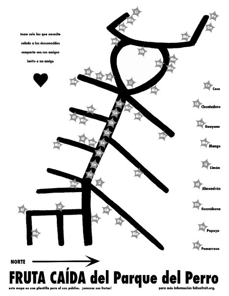
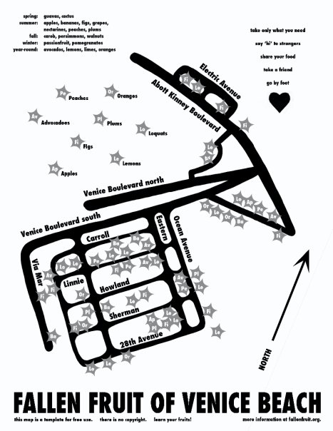
Fallen Fruit's collaboration began in 2004 by mapping the fruit trees growing in public space (sidewalks, streets and alleys) of their neighbourhood. They were intrigued by the fruit growing in public, mostly untended, unharvested and even unnoticed. They termed what they found "Public Fruit" and began to think about how it could be deployed in the discussion about existing neighbourhoods and dreams for urban space. The maps produced are hand-drawn and distributed free from copyright as jpegs and pdfs.
People are encouraged to wander, forage and look, getting a new sense of possibility in a familiar urban space. For this reason, they have avoided geo-tagging online maps, which give exact locations for the trees. The action aims to highlight the speculative aspect of this ongoing project: the examination of how fruit can be used to rethink the way people live, to evoke utopian possibility while being solidly pragmatic.
Goals:
The maps are intended both as a practical guide and a speculative proposition. Not only they do not follow exact spatial proportions, but each map has a certain amount of play in the choice of which streets are included, so that often these express unusual shapes present in the landscape: an animal, a mythical shape of just a gesture used to break the grid on which most cities are built. The maps are intended to make the user rethink the meaning of place, and the use to which the most familiar spaces (our streets and sidewalks) may be put.
Beneficial Outcomes:
The maps have a liminal life of online distribution and they are widely circulated and often copied, which we think is a great recognition. Fallen Fruit often activate the maps by using them to lead tours through actual sites. These tours start in the evening so they can meet the residents and talk to them. The residents are at often as surprised as the people on the tour. The intangible benefit of these maps is most important to them: the emergence of new conversations around cities and neighbourhoods, gardens, public space and the meaning of food. Fallen Fruit believes in a kind of art-making in which the product is social and generative. The purpose of this work is to change the way we think and live in our cities and neighbourhood
Images: